Utility Mapping: the simple way to discover underground utility lines
When digging occurs on a building site, it is likely the worker(s) will come across various utility lines. In order to avoid any prospective pricey damage to these lines, it’s important to employ the services of a utility mapping firm, that will show the construction business a layout of where utility lines can be located.
What is utility mapping?
Underground utility lines can be located by utility mapping businesses, that give construction companies detailed maps of various utility lines’ whereabouts. Utility lines which can be located underground cover anything from mains water lines and sewer pipes, to power wires, television cables and also telephone lines.
Utility mapping businesses offer the customer an up-to-date utility lines layout available as 2D and 3D maps. This doesn’t take a lot of time, and is done via GPS (global positioning system) tools. The utility mapping data is referenced to an arbitrary grid and level datum as standard. The drawing may also be supplied to a specified grid & level datum and/or overlaid on an existing topographical survey. A range of colours can also be used to outline every different utility line – e.g. another colour for water lines along with a different colour for sewerage lines.
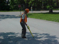
Utility mapping technology
A range of technologies are employed by these companies in order to locate different utility lines. Utility mapping technologies include electromagnetic detection, acoustic detection, ground penetrating radars and live-line detectors. Different techniques need to be implemented to recognize different kinds of matter like metal, plastic, concrete, ceramic or fibre optic components.
Further utility mapping details
The client also can ask for additional details from their utility mapping company. These extra details include fixed surface utility features such as inspection chambers or telegraph poles, and key topographic features like fence lines or kerb lines. Street names, building names as well as house numbers could also be included in the client’s map to help in the site location.
Why employ the services of a utility mapping business?
1. Gain confidence and trust from utility owners
If the business has evidence that they’ve used the services of a utility mapping firm, then the specific owners of the utility lines will have much more trust and confidence in the specific building project (they won’t fear damage to utility lines.)
2. Utilities can be easily located
By using the services of a utility mapping company, a site’s construction and maintenance teams can readily locate various utility lines.
3. Accurate utility map guaranteed
It is necessary to contact a utility mapping company prior to any new construction project. Even if a company is equipped with a utility map already, that specific map might be out-of-date where new maintenance, repair or modifications could have taken place. It may also display utility lines which never actually materialised.
4. Avoid culpability
Utility mapping data is often added to construction designs or building plans. If this particular data isn’t included in the design or plan, your company could be held liable for broken utility lines, resulting in a costly outcome.
5. Health and safety regulations
Businesses can also use utility mapping to comply with health and safety regulations. A utility mapping service is a safe and cost-effective solution for clients who need to undertake excavation works on sites where a record is required for future reference or as With all these different factors outlined, it is also crucial to employ a company with good experience in the utility mapping sector.Detailed maps of underground utilities should be presented in an easy-to-use format and should provide a colour coded drawing of known utilities and key topographic features.
All in all, utility mapping has come a long way with its various modern and advanced technologies. It is a legal requirement to contact the authorities before undergoing any construction process. However, by employing the services of an underground utility mapping service will save your company both money and time.
What is utility mapping?
Underground utility lines can be located by utility mapping businesses, that give construction companies detailed maps of various utility lines’ whereabouts. Utility lines which can be located underground cover anything from mains water lines and sewer pipes, to power wires, television cables and also telephone lines.
Utility mapping businesses offer the customer an up-to-date utility lines layout available as 2D and 3D maps. This doesn’t take a lot of time, and is done via GPS (global positioning system) tools. The utility mapping data is referenced to an arbitrary grid and level datum as standard. The drawing may also be supplied to a specified grid & level datum and/or overlaid on an existing topographical survey. A range of colours can also be used to outline every different utility line – e.g. another colour for water lines along with a different colour for sewerage lines.
Utility mapping technology
A range of technologies are employed by these companies in order to locate different utility lines. Utility mapping technologies include electromagnetic detection, acoustic detection, ground penetrating radars and live-line detectors. Different techniques need to be implemented to recognize different kinds of matter like metal, plastic, concrete, ceramic or fibre optic components.
Further utility mapping details
The client also can ask for additional details from their utility mapping company. These extra details include fixed surface utility features such as inspection chambers or telegraph poles, and key topographic features like fence lines or kerb lines. Street names, building names as well as house numbers could also be included in the client’s map to help in the site location.
Why employ the services of a utility mapping business?
1. Gain confidence and trust from utility owners
If the business has evidence that they’ve used the services of a utility mapping firm, then the specific owners of the utility lines will have much more trust and confidence in the specific building project (they won’t fear damage to utility lines.)
2. Utilities can be easily located
By using the services of a utility mapping company, a site’s construction and maintenance teams can readily locate various utility lines.
3. Accurate utility map guaranteed
It is necessary to contact a utility mapping company prior to any new construction project. Even if a company is equipped with a utility map already, that specific map might be out-of-date where new maintenance, repair or modifications could have taken place. It may also display utility lines which never actually materialised.
4. Avoid culpability
Utility mapping data is often added to construction designs or building plans. If this particular data isn’t included in the design or plan, your company could be held liable for broken utility lines, resulting in a costly outcome.
5. Health and safety regulations
Businesses can also use utility mapping to comply with health and safety regulations. A utility mapping service is a safe and cost-effective solution for clients who need to undertake excavation works on sites where a record is required for future reference or as With all these different factors outlined, it is also crucial to employ a company with good experience in the utility mapping sector.Detailed maps of underground utilities should be presented in an easy-to-use format and should provide a colour coded drawing of known utilities and key topographic features.
All in all, utility mapping has come a long way with its various modern and advanced technologies. It is a legal requirement to contact the authorities before undergoing any construction process. However, by employing the services of an underground utility mapping service will save your company both money and time.
